Showing posts with label boundary. Show all posts

February 11, 2013

overlay as a core GIS concept is not so strong in humanities GIS

The overlay of different information was one of the very first concepts of GIS. Like the core function, the corner stone, the first brick <...> that engaged the development of GIS on which all GIS users stand now. And it remains one of the most popularly used method for data analysis.

This concept is explained in every basic GIS cookbook, more objectively I haven't encountered any book that would not talk about overlay presenting it as a concept, technique, procedure, method. It's always presented in a very simple way by visualizing or explaining boolean operations. What else could be said? Apart from scale, resolution, data uncertainty problematics probably not much more, until we look into the GIS for Humanities (as Standford coins) and GIS concepts start to sway..

GIS concept suitability for social or humanitarian research is well presented in a book "The Spatial Humanities" writen by geographers, historians at the same time having the informatics education. The introduction starts with pointing that "the power of GIS for the humanities lies in its ability to integrate information from a a common location, regardless of format, and to visualize the results in combinations of transparent layers on a map of the geography share by data" and sadly adding that the existing GIS software was created for environmental planning questions and now it "requires humanists fit their questions, data, and methods to the rigid parameters of the software"  which makes it challenging in the extreme fussing GIS with humanities. 

I have personally experienced that while working on cultural areas visualization. And nothing else was as hard as to find a way to visualize just because the concepts themselves were not suitable for my task!

October 09, 2012

digging out the edge of the hill

Recently I had a possibility and time to look practically at the boundary questions, the ones I always like to philosophy about...  I got a simple task: to calculate the volume of a small heap (much smaller then hill) having an image with elevation values (DEM) and so I just needed to automatize and to simplify the steps that were already determined by others, mostly some routine work with ArcGIS (ESRI) tools, so just a bit of patience learning to geoprocess with python.

Digging the boundary  of a heap
But before starting the calculations I had to find out where is this heap and where it's not anymore. I had to draw clear boundaries in order to start some calculations at all. Apparently there was no tool for a heap determination founded where I work, till now all was done manually, by digitizing: zooming out and in, searching out that boundary where the heap starts or ends and going around.
The human brain is great, fast recognizing the pattern it searches for. Maybe recognizing just approximately, but nicely and unconsciously ignoring all other: small depressions, pikes or elevation model noise due to calculated heights of some bushes or some artificial constructions  or photogrametrical noise...
But the problem is that when having a huge images with a great resolution it takes hours and hours to load it and while zooming back and forward trying to draw a line in order to determine "exactly" where the heap starts or/and ends. Besides, when you start looking at a greater and greater resolution the picture of  all the image disappears and for our brain it becomes hard to process just various tones of colours in pixels in front. So, I needed to find how to automatize this first step in order I could work on the calculations. And just looking rather at a simple task or indeed at the DEM (it's prety nice!),  I fastly ran into a dark dark forest searching the way how to determine where this heap finishes or starts in order to be able to define it and build the script.

November 20, 2011

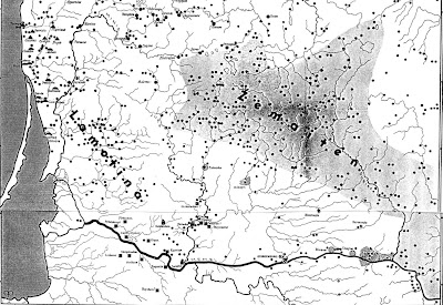
examining boundaries with example of archeological culture

Do exist cultural boundaries? Do cultures bound itself or just scientists draw it?

Social scientists are so much focused on the concept of boundaries, that there is no question it exists. It's long time it's proved people always have some concept of 'us' and of 'them' in their mind, it means socially they make distinctions. And so social scientists are interested in social phenomenas emerging due to such differentiation. There is a whole study of boundaries done. But the boundary concept is not full - it's just social boundary concept, concept mostly defined by self identification which might define or identify ethnos, but not whole ethnical culture and NEITHER archaeological culture. Archeologists define archeological cultures, which may be ethincal cultures, cultures identifying themselves as one, but it is never a rule. All if far from geographical boundaries as well as the culture and it's spread is understood differentially. Geographers try to unite all possible aspects, drawing and presenting the boundaries of cultural regions.

Let's look at some archaeological boundary of Lithuanian archaeological culture drawn.

November 15, 2011

boundary cognition from satellite images

Satellites are swapping around the Earth since 1957 - the launch of Sputnik. Already having a couple of thousands, the number is fast growing nowadays.


Just during the last week reading my rss, I got to know that China has launched Yaogan XII, Vietnam is buying Japanese satellites, Turkish  recently launched satellite RASAT is already transmitting images, Russia is about to launch 4 more GLONASS satellites to existing 28 ones, and so on an so on.. Europe, yes Europe as well, finally launched 2 GALILEO satellites last month. Future, talking about the number of satellites, is amazing..
I am glad we still can see the sky over them.