Showing posts with label humanities GIS. Show all posts

March 11, 2014

why geographers are still scared of Neural Networks?

While discussing with myself on starting a blog about GIS, I was in sort of enlightenment phase, discovering that GIS is not just ArcGIS (as I was once taught.. ) or other GIS systems (QGIS, JumpGIS or GRASS of which I was sort of scared and was just poking it without a reply). I was enlightened with the GISc light - where Sc stands for Science - and though that nearly every problem, if one can rethink it to find the spatial axis, could be maybe solved with GISc. So came the title: if we have a problem we should think in GIS, as thinking is one or the main parts of the science as such. At the same time I played with words to state that "THINKING IS." Luckily, this last meaning will stay forever, as I am less and less sure about the first one. How one can think in GIS (Seriously!)?  We can think.. mathematically, geographically..., logically, but there aren't such expressions as geo-informatically, hm..

The doubts about the SUPER-science - GISc came just after I have started reading on Artificial Neural Networks, and while googling came across the article "GIS & Artificial Neural Networks: Does Your GIS Think?". Of course the GIS in that article stands just for the systems meaning, asking if your system is thinking and all in all article explains just the basics of Neural Networks without really touching GIS as a science. Well, it was just the name that caught me: it is not us that think in GIS, it is GIS itself!? In that case of course my GIS was not thinking.. I was surprised I have not ever heard about Neural Networks in a GIS context and one can say it is my fault, but well, I am a geographer and such topic wasn't popular on the titles in geographical journals. And I have just browsed the online library of Wiley.com.. where:
There are over 90 thousands results for: neural networks, but just 3 of those are in "The Geographical Journal" and all of them are of meeting, review, ceremony.. Well, no article.  
Seems, geographers are not the ones to occupy themselves with such an issue: neural networks! Pff! Or maybe the topic is considered not suitable for the geographical journal?

Of course there are geographers, the so-called-pioneers, that try to bring novelties to the geography. Somehow not all those novelties, like Neural Networks, get accepted.
Seems still recently, but already more then decade ago the geographer Stan Openshaw wrote the book "Artificial Intelligence in Geography" filed with such an enthusiasm! The book was sort of a result of the course he was giving back then ant the University of Leeds. Published by the same Wiley, I was browsing for Neural Networks in a journal section. And already back then, being so enthusiastic about neural network applications in geography, S. Openshaw is repetitively asking in his book with a surprise why geographers aren't still using such a powerful tool! Especially for geographical problems that are non-linear as a rule and thus can't be approximated by mathematical models, nor fitted into interrelation independence assumption. S. Openshaw frankly believes and tries to show that Neural Networks is the option we are looking for.

Really, why don't geographers use neural networks ? Already back then, in 1997 S. Openshaw was happily expecting the upcoming "golden age" for "Thinking GIS", "Thinking Geography" and it never came.. It is surely not because of difficulty as it is the easiest technique to use - one doesn't really need to understand much, how the technique thinks, one just needs to choose the data for the thing he aims.
Magic hand black box!
(found on ebay)
Maybe it is all because of that mystery that is within the technique, called as black-box. One cannot control much of the process how the output is created. Neural networks do it themselves. They are simply trained by being fed loads of data and the expected result. The relations, how from input data get the expected result are constructed or learned by the network itself approximating his guesses and minimizing the error. But well, one does not even need to understand this to use it. What geographers really need, in my opinion, is simply clearly to say - a great interface and great mapping possibility, thus great graphics, or else Neural Networks will stay as scary as GRASS. And although I'm laughing here, but well, I did not meet much of geographers, especially the social geographers, using GRASS software. Sure software easy to use might not be enough (as there are some already), one would need to make it well accessible(like not too expensive) or commercialized to such extent that even small business would go crazy to have it and so it would be even taught at the university. But, of course you never know.. Maybe that "golden ANN age" will come to geography as well, already being so popular in hydrology, meteorology and geotechnical problems.

February 11, 2013

overlay as a core GIS concept is not so strong in humanities GIS

The overlay of different information was one of the very first concepts of GIS. Like the core function, the corner stone, the first brick <...> that engaged the development of GIS on which all GIS users stand now. And it remains one of the most popularly used method for data analysis.

This concept is explained in every basic GIS cookbook, more objectively I haven't encountered any book that would not talk about overlay presenting it as a concept, technique, procedure, method. It's always presented in a very simple way by visualizing or explaining boolean operations. What else could be said? Apart from scale, resolution, data uncertainty problematics probably not much more, until we look into the GIS for Humanities (as Standford coins) and GIS concepts start to sway..

GIS concept suitability for social or humanitarian research is well presented in a book "The Spatial Humanities" writen by geographers, historians at the same time having the informatics education. The introduction starts with pointing that "the power of GIS for the humanities lies in its ability to integrate information from a a common location, regardless of format, and to visualize the results in combinations of transparent layers on a map of the geography share by data" and sadly adding that the existing GIS software was created for environmental planning questions and now it "requires humanists fit their questions, data, and methods to the rigid parameters of the software"  which makes it challenging in the extreme fussing GIS with humanities. 

I have personally experienced that while working on cultural areas visualization. And nothing else was as hard as to find a way to visualize just because the concepts themselves were not suitable for my task!

November 20, 2011

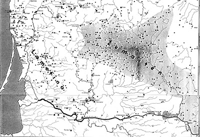
examining boundaries with example of archeological culture

Do exist cultural boundaries? Do cultures bound itself or just scientists draw it?

Social scientists are so much focused on the concept of boundaries, that there is no question it exists. It's long time it's proved people always have some concept of 'us' and of 'them' in their mind, it means socially they make distinctions. And so social scientists are interested in social phenomenas emerging due to such differentiation. There is a whole study of boundaries done. But the boundary concept is not full - it's just social boundary concept, concept mostly defined by self identification which might define or identify ethnos, but not whole ethnical culture and NEITHER archaeological culture. Archeologists define archeological cultures, which may be ethincal cultures, cultures identifying themselves as one, but it is never a rule. All if far from geographical boundaries as well as the culture and it's spread is understood differentially. Geographers try to unite all possible aspects, drawing and presenting the boundaries of cultural regions.

Let's look at some archaeological boundary of Lithuanian archaeological culture drawn.